
Export Formats
- Document
- Developers — Export Formats
- Chapters
- 7
- Source
- help.dronetag.cz/print/developers/export-formats
Which Export to Choose
Dronetag exports flights and detections in a few file formats. The formats are the same wherever you export from, for example the Dronetag App, the Dronetag Export service or your own software through the Dronetag API. This section describes the files. What you can choose in each place is described on that place's own page, such as Exporting Data in the Dronetag App.
This page helps you pick a format.
A flight is reported by a Dronetag device on your own drone. A detection is a drone that one or more of your receivers heard, for example a Dronetag Scout. Flights and detections use the same file formats. A detection fills in a few extra fields, such as which receiver heard it.
Pick a Format
| I want to | Choose | Read more |
|---|---|---|
| Replay a flight in 3D | KMZ | KMZ for Google Earth |
| Give someone a printable report | One report per flight or detection | |
| Work with every position in Excel | CSV, With tracks | CSV Telemetry |
| List many flights in Excel, one row each | CSV, Summary | CSV Summary |
| Feed my own software | JSON | JSON |
KML is the same map as KMZ, but without the icons and the colour legend. Google Earth shows its own default pins instead. Choose KML only if a tool can't open KMZ.
With Tracks or Summary
JSON and CSV come in two versions. You pick one when you export.
- With tracks has every recorded position. This is the default.
- Summary has one entry per flight or detection, without the positions.
The figures in a Summary are still calculated from the whole track. Choose Summary when you export many flights. For 80 flights, a Summary is a few hundred kilobytes and With tracks is tens of megabytes.
Units and Times
JSON and CSV always use metres, metres per second, degrees and seconds. Their times are in UTC.
KMZ and PDF use metric units, or imperial ones where the place you export from lets you choose. Their times are also in UTC, marked "(UTC)".
File Names
| You exported | File name |
|---|---|
| 80 flights from 1 to 7 May 2026 | dronetag-flights-80_20260501-20260507-telemetry.csv |
| One flight | dronetag-flight_1596CEXAMPLE00001_20260917-0742Z-telemetry.csv |
Detections say operations or operation instead of flights or flight. A Summary ends in -summary instead of -telemetry. A zip has the same name with the extension .zip. Dates and times in file names are in UTC.
Format Versions
JSON, CSV Telemetry and CSV Summary are all version 1.0, and each has its own version. When something is only added, the second number goes up. When something is removed, renamed or changes meaning, the first number goes up. If your software reads JSON, read schema_version and check the first number before you read the rest.
When You Get a Zip File
A CSV can arrive in a zip together with a file called ATTRIBUTION.txt. This happens when heights in the CSV were calculated from terrain data that must be credited. Keep the two files together when you pass the data on. See Terrain Data and Attribution.
Some places also put several formats, or a large selection split into parts, into one zip.
Files Safe to Share Publicly
Some places can make a file that is safe to share publicly. The file then leaves out the pilot's name and ID, the pilot's positions and the take-off point. It also leaves out the callsign, the Self-ID text, the return-to-home point and the receivers that heard a detection.
Serial numbers keep their first four and last four characters. Registration numbers and operator IDs are hidden completely. The drone's own track stays in the file.
Example Files
The examples on these pages come from these files. They are synthetic. Every name, serial number, receiver and registration in them is invented.
| File | What it shows |
|---|---|
| telemetry-1-flight.json | JSON With tracks, one flight |
| telemetry-1-detection.json | JSON With tracks, one detection with its pilot positions |
| summary-3-flights.json | JSON Summary, three flights |
| summary-3-detections.json | JSON Summary, three detections |
| telemetry-1-flight.csv | CSV Telemetry, one flight |
| telemetry-1-detection.csv | CSV Telemetry, one detection |
| summary-3-flights.csv | CSV Summary, three flights |
| summary-3-detections.csv | CSV Summary, three detections |
| ATTRIBUTION.txt | The terrain credits that come in a zip with a CSV |
In a real download the file names follow the pattern under File Names, and each of these CSVs would arrive in a zip with its ATTRIBUTION.txt.
CSV Telemetry
CSV Telemetry is the CSV you get with With tracks. It has one row for every recorded position. The file name ends in -telemetry.csv.
Flights and detections use the same 15 columns in the same order. A column that one kind never fills stays empty.
Columns
| # | Column | Meaning | Unit | Empty when | In JSON |
|---|---|---|---|---|---|
| 1 | operation_id | ID of the flight or detection | operations[].id | ||
| 2 | timestamp | Time of the position, UTC | track[].timestamp | ||
| 3 | serial_number | Serial number. For a flight, the Dronetag device's. | Not reported | Identifier of type serial_number | |
| 4 | sensor_id | Receiver that heard this position | Flights, or shared publicly | track[].sensor_id | |
| 5 | operational_state | grounded, airborne or emergency | Flights, or not reported | track[].operational_state | |
| 6 | latitude | Latitude, WGS 84 | degrees | track[].location.latitude | |
| 7 | longitude | Longitude, WGS 84 | degrees | track[].location.longitude | |
| 8 | horizontal_speed | Speed over the ground | m/s | Not reported | track[].velocity.horizontal_speed |
| 9 | vertical_speed | Climb rate, positive when climbing | m/s | Not reported | track[].velocity.vertical_speed |
| 10 | heading | Direction of travel, clockwise from north | degrees | Not reported | track[].velocity.heading |
| 11 | alt_hae_wgs84 | Height above the WGS 84 ellipsoid | m | Not reported | Altitude of type HAE-WGS84 |
| 12 | alt_ato | Height above the take-off point | m | Not reported | Altitude of type ATO |
| 13 | alt_pressure | Pressure altitude | m | Not reported | Altitude of type PA-QNE |
| 14 | alt_msl | Altitude above mean sea level | m | Can't be worked out | Altitude of type MSL |
| 15 | alt_agl | Height above the ground | m | No sea level or no terrain data | Altitude of type AGL |
The five altitude columns are explained in Altitudes Explained.
An empty cell means the value wasn't reported and Dronetag couldn't calculate it. A real zero, such as the speed of a hovering drone, is written as zero and never left empty.
CSV has no accuracies. If you need to know how exact a value is, use JSON.
Facts about the aircraft and the pilot are in CSV Summary. Its id column holds the same value as operation_id, so you can join the two files.
Example
The first row of the example flight and of the example detection (synthetic data):
operation_id,timestamp,serial_number,sensor_id,operational_state,latitude,longitude,horizontal_speed,vertical_speed,heading,alt_hae_wgs84,alt_ato,alt_pressure,alt_msl,alt_agl
3f6b1c2e-8d4a-4b7f-9e21-5a0c7d3e9b14,2026-09-17T07:42:13.350390Z,1596CEXAMPLE00001,,,49.1679989,16.4950113,0.0,0.0,,327.1,0.08,255.81,282.13207082568454,0.43031044931819906
6d2f8a41-93c7-4e0b-b5d2-1f7a9c3e8b60,2026-09-22T15:31:04.048000Z,1581FEXAMPLE00000004,SCT-EXAMPLE-01,grounded,49.9599978,14.4999964,0.0,0.0,0.0,400.3,0.0,327.7,354.9,1.0917571914229143
The flight row has no receiver and no state. The detection row has both.
Opening It in Excel
A CSV is written in one of two styles. Some places let you choose the style when you export.
- Decimal point writes
1.5and separates columns with commas. It suits English-language Excel, Numbers and LibreOffice. - Decimal comma writes
1,5and separates columns with semicolons. It suits Czech, German and most other European set-ups.
When the style matches your Excel, double-click the file and it opens in columns. Accents and the degree sign display correctly.
If everything lands in one column, the file was written in the other style. Import it instead.
- In Excel, choose Data → From Text/CSV and pick the file.
- Set the delimiter to comma or semicolon.
- If numbers come out as text, choose Transform Data, select the columns and use Change Type → Using Locale.

Numbers keep every digit the source reported. Format the cells in Excel if you want fewer decimals.
Reading It in a Program
The file is UTF-8 with a byte order mark. In Python, open it with encoding="utf-8-sig". Lines end in CRLF and times end in Z (UTC). Numbers have full precision and no thousands separators. The header always has the same 15 columns.
If You Get a Zip File
When alt_msl or alt_agl came from terrain data that must be credited, the CSV arrives in a zip with ATTRIBUTION.txt. Keep the two files together. See Terrain Data and Attribution.
CSV Summary
CSV Summary is the CSV you get with Summary. It has one row for each flight or detection. It doesn't contain the positions.
The file name ends in -summary.csv.
Flights and detections use the same 37 columns in the same order. The figures are calculated from the whole track, exactly as in a With tracks export.
Columns
The Who column says which kind fills the column. F means flights, D means detections.
Identity
| # | Column | Who | Meaning | Unit | Empty when | In JSON |
|---|---|---|---|---|---|---|
| 1 | id | F D | ID of the flight or detection | Never | id | |
| 2 | status | F D | See Status values | Not reported | summary.status | |
| 3 | sensor_ids | D | Receivers that heard it, separated by | | Flights | summary.source.sources[].name | |
| 4 | serial_number | F D | Serial number. For a flight, the Dronetag device's. | Not reported | Identifier of type serial_number | |
| 5 | callsign | F D | Name the pilot gave the flight, or a manned aircraft's callsign | Not set | Identifier of type custom_callsign, otherwise callsign | |
| 6 | caa_assigned | D | Registration number from the aviation authority | Not broadcast | Identifier of type caa_assigned |
Aircraft and Operator
| # | Column | Who | Meaning | Unit | Empty when | In JSON |
|---|---|---|---|---|---|---|
| 7 | aircraft_manufacturer | D | Manufacturer, such as DJI | Unknown | summary.aircraft_manufacturer | |
| 8 | aircraft_model | F D | Model, such as DJI Mavic 3 | Unknown | summary.aircraft_model | |
| 9 | aircraft_category | D | Kind of aircraft, such as rotorcraft | Unknown | summary.aircraft_category | |
| 10 | ua_classification | D | EU category and class, such as open class_1 | Not broadcast | summary.ua_classification category and class | |
| 11 | uas_operator_id | F D | Operator registration number | Not reported | summary.uas_operator_id | |
| 12 | pilot_id | F | Pilot's ID in the Dronetag platform | Detections | summary.pilot.id | |
| 13 | pilot_name | F | Pilot's name | Detections | summary.pilot.name | |
| 14 | message_count | D | Messages heard by all receivers together | Flights | summary.message_count |
When
| # | Column | Who | Meaning | Unit | Empty when | In JSON |
|---|---|---|---|---|---|---|
| 15 | duration | F D | From the first to the last position | s | No positions | summary.duration |
| 16 | time_first_telemetry | F D | Time of the first position, UTC | No positions | summary.time_first_telemetry | |
| 17 | time_last_telemetry | F D | Time of the last position, UTC | No positions | summary.time_last_telemetry |
Where
| # | Column | Who | Meaning | Unit | Empty when | In JSON |
|---|---|---|---|---|---|---|
| 18, 19 | take_off_latitude, take_off_longitude | F (D rarely) | Take-off location | degrees | Not reported | summary.take_off.location |
| 20, 21 | first_latitude, first_longitude | F D | First position | degrees | No positions | summary.first |
| 22, 23 | last_latitude, last_longitude | F D | Last position | degrees | No positions | summary.last |
| 24, 25 | min_latitude, max_latitude | F D | Southern and northern edge of the track | degrees | No positions | summary.bbox[1], summary.bbox[3] |
| 26, 27 | min_longitude, max_longitude | F D | Western and eastern edge of the track | degrees | No positions | summary.bbox[0], summary.bbox[2] |
The first and last positions are where the record starts and ends. They are often not the take-off and landing, because a receiver starts hearing a drone when it comes into range.
How Far and How Fast
| # | Column | Who | Meaning | Unit | Empty when | In JSON |
|---|---|---|---|---|---|---|
| 28 | point_count | F D | Number of positions | No positions | summary.point_count | |
| 29 | total_distance | F D | Distance flown over the ground | m | Fewer than 2 positions | summary.total_distance |
| 30 | max_horizontal_speed | F D | Highest ground speed | m/s | No speed reported | summary.max_horizontal_speed |
| 31 | operator_track_kind | D | operator, take_off or mixed, see below | No pilot position | summary.operator_track_kind | |
| 32 | max_operator_distance | D | Largest distance between drone and pilot | m | No pilot position | summary.max_operator_distance |
| 33 | operator_movement_extent | D | How far the pilot moved | m | No pilot position | summary.operator_movement_extent |
| 34 | transmission_technologies | D | How the drone was heard, such as wifi_beacon, separated by | | Flights | summary.source.transmission_technologies |
operator_track_kind tells you what the pilot position is. operator is the pilot's real position. take_off means the drone sent only its take-off location, so the distances are measured from there. mixed is some of each.
Altitudes
| # | Column | Who | Meaning | Unit | Empty when | In JSON |
|---|---|---|---|---|---|---|
| 35 | max_alt_ato | F D | Highest height above take-off | m | Not in the track | summary.max_altitudes[] of type ATO |
| 36 | max_alt_msl | F D | Highest altitude above sea level | m | Not in the track | summary.max_altitudes[] of type MSL |
| 37 | max_alt_agl | F D | Highest height above the ground | m | Not in the track | summary.max_altitudes[] of type AGL |
There are no minimums. See Altitudes Explained.
Status Values
| Value | Kind | Meaning |
|---|---|---|
planned | Flight | Created ahead of time and not started yet |
current | Flight, detection | Still in progress when you exported it. The track may still grow. |
inactive | Flight | Still open, but the device stopped reporting |
uploading | Flight | Recorded offline and still being uploaded |
processing | Flight | Over, and still being processed |
error | Flight | Processing failed, so the record may be incomplete |
finished | Flight | Over and processed |
cancelled | Flight | Planned and never flown |
past | Detection | Over |
upcoming | Detection | Announced and not started yet |
Only in JSON
CSV Summary keeps to the fields most people need. These are only in JSON:
- Accuracies.
- Start and end times as the source states them. These can differ from the first and last position.
- The return-to-home point and the declared operation area of a flight.
- Rare identifiers, the Self-ID text and the flight's colour.
Example
One example flight and one example detection (synthetic data):
id,status,sensor_ids,serial_number,callsign,caa_assigned,aircraft_manufacturer,aircraft_model,aircraft_category,ua_classification,uas_operator_id,pilot_id,pilot_name,message_count,duration,time_first_telemetry,time_last_telemetry,take_off_latitude,take_off_longitude,first_latitude,first_longitude,last_latitude,last_longitude,min_latitude,max_latitude,min_longitude,max_longitude,point_count,total_distance,max_horizontal_speed,operator_track_kind,max_operator_distance,operator_movement_extent,transmission_technologies,max_alt_ato,max_alt_msl,max_alt_agl
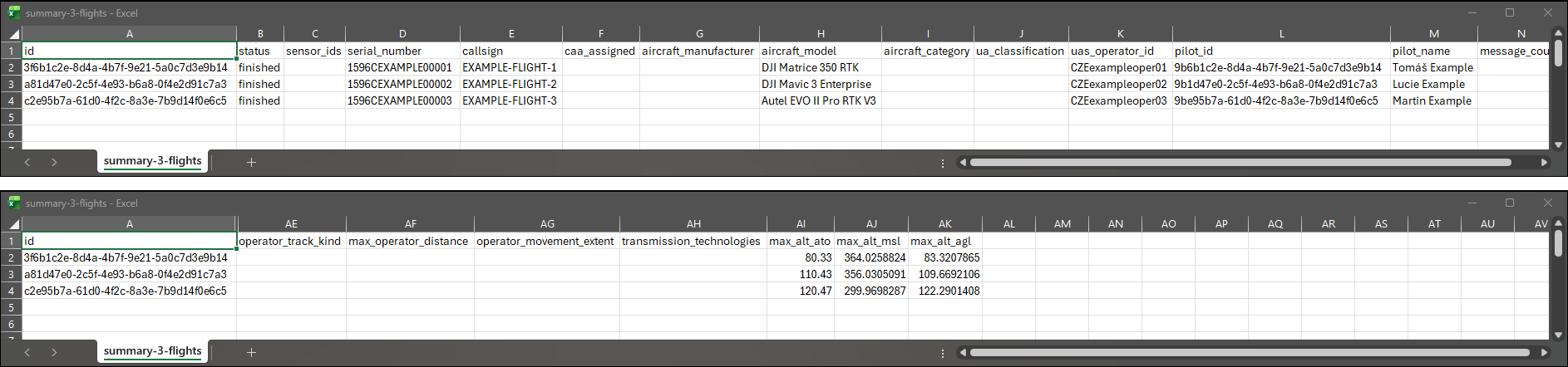
3f6b1c2e-8d4a-4b7f-9e21-5a0c7d3e9b14,finished,,1596CEXAMPLE00001,EXAMPLE-FLIGHT-1,,,DJI Matrice 350 RTK,,,CZEexampleoper01,9b6b1c2e-8d4a-4b7f-9e21-5a0c7d3e9b14,Tomáš Example,,260.963047,2026-09-17T07:42:13.350390Z,2026-09-17T07:46:34.313437Z,49.1679989,16.4950113,49.1679989,16.4950113,49.168003,16.4949982,49.167991,49.1699201,16.4949881,16.4979653,262,1373.6529667703585,10.14401301260995,,,,,80.33,364.0258824461374,83.32078650204227
6d2f8a41-93c7-4e0b-b5d2-1f7a9c3e8b60,past,SCT-EXAMPLE-01|SCT-EXAMPLE-02,1581FEXAMPLE00000004,,OK-UAS-EXAMPLE-4,DJI,DJI Mavic 3,rotorcraft,open class_1,CZEexampleoper04,,,194,192.977,2026-09-22T15:31:04.048000Z,2026-09-22T15:34:17.025000Z,,,49.9599978,14.4999964,49.9599977,14.4999876,49.9599864,49.9620193,14.4999838,14.5036452,194,973.7599886011964,12.16,operator,261.9408504975598,44.46384785221796,wifi_beacon|wifi_nan,95.1,449.4,97.37793678299658
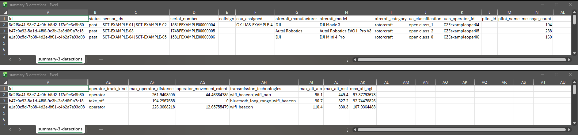
The same columns for three flights. The detection-only columns stay empty.
Joining It With CSV Telemetry
id here and operation_id in CSV Telemetry hold the same value. Put both files in one workbook, with the summary on a sheet called Summary. In the telemetry sheet, add a column with this formula:
=XLOOKUP(A2, Summary!A:A, Summary!H:H)
It copies aircraft_model (column H) into each position row. If your Excel separates formula arguments with semicolons, use semicolons instead of the commas.
Cells With Several Values
sensor_ids and transmission_technologies can hold several values separated by |. If a value itself contains | or \, a backslash is written in front of it.
Reading It in a Program
The rules are the same as for CSV Telemetry. The file is UTF-8 with a byte order mark, lines end in CRLF and times are in UTC. The header always has the same 37 columns.
JSON
JSON is the complete export, meant for your own software. It has everything the CSV files have, plus accuracies, all identifiers, the pilot's positions and the terrain credits. The current version is 1.0.
- With tracks has every flight or detection with all its positions. The file name ends in
-telemetry.json. - Summary is the same file without
trackandoperator_track. Everything else is identical. The file name ends in-summary.json.
The file is written on one line to keep it small. To read it, open it in a code editor and format it, or run jq . file.json.
Where DUMP (Dronetag Unified Message Protocol) has a name and shape for something, the export uses it. The JSON Schema of the file is published at:
https://api.dronetag.app/v2/export/schemas/export-v1.json
This page describes the file. The export endpoints are described in the Dronetag API documentation.
The Shape of the File
{ schema_version, operations: [ { id, summary, operator_track, track }, … ], attribution }
| Key | Type | Present | What it is |
|---|---|---|---|
schema_version | string | Always | "1.0" |
operations[] | array | Always | The flights and detections |
attribution | object | When needed | Terrain credits for the whole file. See Attribution. |
summary.source.kind tells you what each entry is. rid_transmitter is a flight from a Dronetag device, rid_receiver is a detection and network_rid is network Remote ID.
The Who column in the tables on this page says which kind fills a key. F means flights, D means detections, F D means both when the source stated it.
Each entry has up to four keys, always in this order.
| Key | Type | Who | What it is |
|---|---|---|---|
id | string | F D | ID of the flight or detection, the same as in the CSV files |
summary | object | F D | Everything about it. First what the source reported, then what Dronetag calculated from the track. Identical in both exports. |
operator_track[] | array of operator points | D | The pilot's positions. With tracks only. |
track[] | array of track points | F D | The aircraft's positions. Always the last key. With tracks only. |
CSV Summary is a flat copy of summary.
When a value wasn't reported and couldn't be calculated, its key is left out. It is never null and never replaced by zero.
Positions and Altitudes
A track point from the example detection, formatted for reading:
{
  "timestamp": "2026-09-22T15:31:25.923000Z",
  "timestamp_accuracy": 0.1,
  "sensor_id": "SCT-EXAMPLE-01",
  "operational_state": "airborne",
  "location": { "latitude": 49.9600514, "longitude": 14.5000551, "accuracy": 3.0 },
  "altitudes": [
    { "type": "HAE-WGS84", "value": 459.4, "accuracy": 10.0 },
    { "type": "MSL", "value": 413.9 },
    { "type": "ATO", "value": 60.9 },
    { "type": "PA-QNE", "value": 388.6 },
    { "type": "AGL", "value": 59.99999999999994, "accuracy": 10.009657003780566 }
  ],
  "velocity": { "horizontal_speed": 9.12, "vertical_speed": 0.83, "heading": 32.7, "speed_accuracy": 0.3 }
}
altitudes is a list with one item per kind of altitude. Look items up by type, not by their place in the list. The five types are explained in Altitudes Explained.
accuracy says how exact a value is, in metres (m/s for speeds). Roughly two times in three, the true value is within this amount. It appears only when the source reported it or Dronetag calculated it.
Two keys list longitude before latitude, because they follow the GeoJSON standard. They are summary.bbox (west, south, east, north) and summary.operation_area. Everywhere else latitude and longitude are named keys.
A Short Example
The example detection, shortened. … marks what was left out.
{
  "schema_version": "1.0",
  "operations": [
    {
      "id": "6d2f8a41-93c7-4e0b-b5d2-1f7a9c3e8b60",
      "summary": {
        "source": {
          "kind": "rid_receiver",
          "transmission_technologies": ["wifi_beacon", "wifi_nan"],
          "sources": [
            { "name": "SCT-EXAMPLE-01", "type": "rid_receiver", "message_count": 66 },
            { "name": "SCT-EXAMPLE-02", "type": "rid_receiver", "message_count": 128 }
          ]
        },
        "identifiers": [
          { "type": "caa_assigned", "value": "OK-UAS-EXAMPLE-4" },
          { "type": "serial_number", "value": "1581FEXAMPLE00000004" },
          …
        ],
        "uas_operator_id": "CZEexampleoper04",
        "ua_classification": { "type": "european_union", "category": "open", "class": "class_1" },
        …
        "aircraft_model": "DJI Mavic 3",
        "status": "past",
        …
        "duration": 192.977,
        …
        "point_count": 194,
        "total_distance": 973.7599886011964,
        …
        "max_altitudes": [
          { "type": "HAE-WGS84", "value": 494.7, "accuracy": 3.0 },
          …
          { "type": "AGL", "value": 97.37793678299658, "accuracy": 3.0320345204719112 }
        ],
        "operator_track_kind": "operator",
        "max_operator_distance": 261.9408504975598,
        …
      },
      "operator_track": [
        { "timestamp": "2026-09-22T15:31:04.091000Z",
          "location": { "latitude": 49.9599127, "longitude": 14.4998279, "accuracy": 4.0 },
          "altitudes": [{ "type": "HAE-WGS84", "value": 401.4 }],
          "source_type": "dynamic" },
        …
      ],
      "track": [ … 194 points like the one above … ]
    }
  ],
  "attribution": {
    "terrain_credits": ["„ČÚZK, 2026“ … by Dronetag"]
  }
}
The complete example files can be downloaded from Which Export to Choose.
Every Key
Summary Keys Stated by the Source
These come first in summary, in this order.
| Key | Type | Who | Description |
|---|---|---|---|
source | object | F D | Where the data come from. See Source. |
identifiers[] | array of {type, value} | F D | Types per DUMP. For drones serial_number, caa_assigned (registration from the aviation authority), utm_assigned, specific_session_id, custom_callsign (the name the pilot gave the flight). For manned aircraft callsign, icao_address, registration, squawk_code, flarm_id, ogn_address. Also other. A flight has serial_number (the device's) and custom_callsign. |
uas_operator_id | string | F D | The UAS operator's registration number |
ua_classification | object {type, category, class} | D | type is european_union. category is open, specific or certified. class is class_0 to class_6. |
aircraft_category | string | D | DUMP value, for example rotorcraft (helicopter and multirotor), aeroplane, glider or unknown. The full list of 28 values is in the JSON Schema. |
aircraft_manufacturer | string | D | Manufacturer |
aircraft_model | string | F D | Full model name, usually starting with the manufacturer, for example DJI Mavic 3 |
descriptions[] | array of {type, value} | F D | Types text_description (Self-ID text), emergency_description, extended_status_description, custom_color. The callsign is not here. It is in identifiers as custom_callsign. |
status | string | F D | The values and their meaning are listed in CSV Summary. |
pilot | object {id, name} | F | The pilot. Removed when the export is made safe to share publicly. |
time_start, time_end | string (time) | F D | Start and end as the source states them. These are not the first and last positions. |
take_off | point object | F (D rarely) | Take-off location as the source states it |
home_location | point object | F D | Return-to-home point, if the source states it |
operation_area | object | F | The declared area, exactly the GeoJSON the source sends. Any geometry or Feature, longitude before latitude. |
Source
| Key | Type | Who | Description |
|---|---|---|---|
kind | string | F D | rid_transmitter (a flight from a Dronetag device), network_rid (network Remote ID) or rid_receiver (a detection) |
standard | string | F D | The Remote ID standard, if the source states it |
transmission_technologies[] | array of string | D | DUMP 0.15 values. Remote ID wifi_beacon, wifi_nan, bluetooth_legacy, bluetooth_long_range. Manned aviation ads_b, ads_l, uat, flarm, ogn. Also ocusync and external. |
sources[] | array of {name, type, position, message_count} | D | The receivers that heard the operation. name is the receiver ID, type is rid_receiver, position is a point object when known and message_count is how many messages it heard. |
Track Point
| Key | Type, unit | Who | Description |
|---|---|---|---|
timestamp | string (time) | F D | Time of the position |
timestamp_accuracy | number, s | D | Stated accuracy of the time |
sensor_id | string | D | The receiver that heard the position |
operational_state | string | D | grounded, airborne or emergency |
location | object | F D | latitude and longitude in degrees (WGS 84), accuracy in metres when stated |
altitudes[] | array of altitude items | F D | Every altitude of the point |
velocity | object | F D | horizontal_speed (m/s), vertical_speed (m/s, positive up), heading (degrees clockwise from north), speed_accuracy (m/s). Also turn_rate (degrees per second), components (east, north and up speed in m/s) and components_accuracy (m/s). Each key only when stated. |
rssi | number, dBm | D | Signal strength, only when the source states it |
Altitude Item
| Key | Type, unit | Description |
|---|---|---|
type | string | HAE-WGS84, MSL, ATO, PA-QNE or AGL. See Altitudes Explained. |
value | number, m | The value |
accuracy | number, m | One standard deviation. When it is present is described in Altitudes Explained. |
A flight from a Dronetag device usually has HAE-WGS84, ATO and PA-QNE. A detection usually has HAE-WGS84 and PA-QNE, often ATO and sometimes MSL stated by the source. Dronetag adds MSL when the source didn't state it and it can be calculated, and AGL when terrain data is available.
Point Object
Used for take_off, home_location and sources[].position.
{"location":{"latitude":49.1679989,"longitude":16.4950113},"altitudes":[{"type":"HAE-WGS84","value":327.1},{"type":"PA-QNE","value":255.81}]}
| Key | Type | Description |
|---|---|---|
location | object | latitude and longitude in degrees, accuracy in metres when stated |
altitudes[] | array of altitude items | The altitudes the source stated for the point. May be empty. |
Operator Point
| Key | Type | Description |
|---|---|---|
timestamp | string (time) | Time of the position |
location | object | As in a track point |
altitudes[] | array of altitude items | When the source stated them |
source_type | string | dynamic (the pilot's real position over time), fixed (stated once) or take_off (the take-off location sent in place of the pilot's position) |
Summary Keys Calculated by Dronetag
These follow the source keys in summary and are identical in both exports.
| Key | Type, unit | Who | Description |
|---|---|---|---|
time_first_telemetry, time_last_telemetry | string (time) | F D | First and last received position |
duration | number, s | F D | The difference of the two |
first, last | object {latitude, longitude} | F D | First and last position in degrees |
bbox | array of 4 numbers | F D | Envelope of the track as a GeoJSON bbox, [min_lon, min_lat, max_lon, max_lat] |
point_count | integer | F D | Number of received positions |
total_distance | number, m | F D | Horizontal distance flown. Small movement while standing still is not counted. |
max_horizontal_speed | number, m/s | F D | Highest ground speed |
max_altitudes[] | array of altitude items | F D | The highest value of each altitude type in the track, with the accuracy of the point where it occurred (only when that point has one). There are no minimums. |
operator_track_kind | string | D | operator (real positions), take_off (take-off location only) or mixed |
max_operator_distance | number, m | D | Largest horizontal distance between the aircraft and the pilot, or the take-off location |
operator_movement_extent | number, m | D | Diagonal of the envelope of the pilot's positions |
message_count | integer | D | Messages heard by all receivers together |
Attribution
{"terrain_credits":["…"],"terrain_liability_notices":["…"]}
| Key | Type | Description |
|---|---|---|
terrain_credits[] | array of string | The credit each terrain model's licence requires, word for word, each text once |
terrain_liability_notices[] | array of string | The legal notice, when a licence requires one, each text once |
The credits belong to the whole file, not to an operation. When they appear and why they must stay with the data is described in Terrain Data and Attribution.
Altitudes Explained
A drone's height can be measured from several starting points, and Remote ID reports several of them. The exports keep each one under its own name, so you always know which one you are reading.
| JSON type | CSV column | Measured from | Comes from |
|---|---|---|---|
HAE-WGS84 | alt_hae_wgs84 | The WGS 84 ellipsoid, the smooth model of the Earth that GPS uses | The drone (GPS) |
MSL | alt_msl | Mean sea level | The drone, or calculated by Dronetag |
ATO | alt_ato | The take-off point | The drone |
PA-QNE | alt_pressure | Standard air pressure (1013.25 hPa) | The drone (barometer) |
AGL | alt_agl | The ground under the drone | Calculated by Dronetag |
All values are in metres.

One Point, Five Altitudes
A point from the example detection, about 60 m above the ground:
| Type | Value | What it means |
|---|---|---|
HAE-WGS84 | 459.4 m | Height above the ellipsoid. In Czechia the ellipsoid lies about 45 m below sea level, so this number is the highest. |
MSL | 413.9 m | Altitude above sea level |
ATO | 60.9 m | Height above the place it took off from |
AGL | 60.0 m | Height above the ground under it. It is close to ATO here because the ground is about as high as at take-off. On a slope the two differ. |
PA-QNE | 388.6 m | The barometer's reading. It is 25 m off the sea-level altitude because real air pressure is never exactly standard. |
Which One to Use
| Question | Use |
|---|---|
| How high above the ground? | AGL |
| How high above where it took off? | ATO |
| How high above sea level, for example to compare with airspace limits? | MSL |
| What did the GPS say? | HAE-WGS84 |
Pressure altitude changes with the weather and isn't corrected for local air pressure. Don't use it as height above sea level.
Why the height above take-off can be negative, and why many drones show it as "AGL", is explained in Understanding Altitude Values.
When MSL Is Empty
If the drone reported a sea-level altitude, the export keeps it. Otherwise Dronetag calculates one from the GPS height. If there is no GPS height, Dronetag uses the height of the take-off point plus the height above take-off.
When none of this is possible, MSL is empty. The file doesn't say which way the value was found.
When AGL Is Empty
AGL is the sea-level altitude minus the height of the ground at that place. The ground height comes from a terrain model. AGL is empty when there is no sea-level altitude or no terrain data for that place. See Terrain Data and Attribution.
A height slightly below zero is normal for a drone standing on the ground. The example flight starts at 0.43 m and goes down to -1.04 m before take-off. Values this close to zero mean "on the ground".
Over forest and in towns, AGL can read low. Some terrain models measure the top of trees and roofs, not the soil.
Accuracy
In JSON, an altitude can have an accuracy in metres. Roughly two times in three, the true value is within this amount.
- A value the drone reported has an accuracy only if the drone reported one.
AGLhas an accuracy.- A calculated
MSLhas one when the value it was calculated from had one. It also includes the error of the conversion, 0.4 m through the geoid or 3.5 m through the take-off point.
CSV files have no accuracies. KMZ and PDF show the height above ground as an estimate, for example "97 m (estimated, ±3.0 m)".
KMZ and PDF calculate the height above ground from the GPS height. When a drone also reported its own sea-level altitude, their figure can differ a little from the one in JSON and CSV.
Altitudes in the Summary
The summary of each flight or detection has the highest value of each altitude type. In JSON this is max_altitudes. In CSV Summary it is max_alt_ato, max_alt_msl and max_alt_agl. There are no minimums.
KMZ for Google Earth
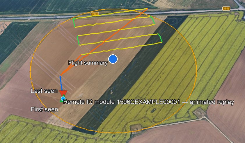
A KMZ file shows your flights or detections on a 3D map. You can replay them, see where the pilot stood and click a marker for details. Open the file in Google Earth Pro. Most GIS tools can import it too.
Heights are drawn above sea level, so the track sits at the right height over the terrain in Google Earth.
What Is in the File
Each flight or detection has its own folder, named after its serial number. Inside, every layer is a folder with its own checkbox in the Places panel, so you can turn layers on and off.
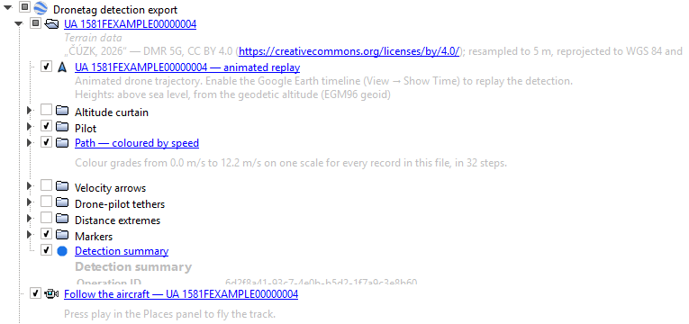
Shown When You Open the File
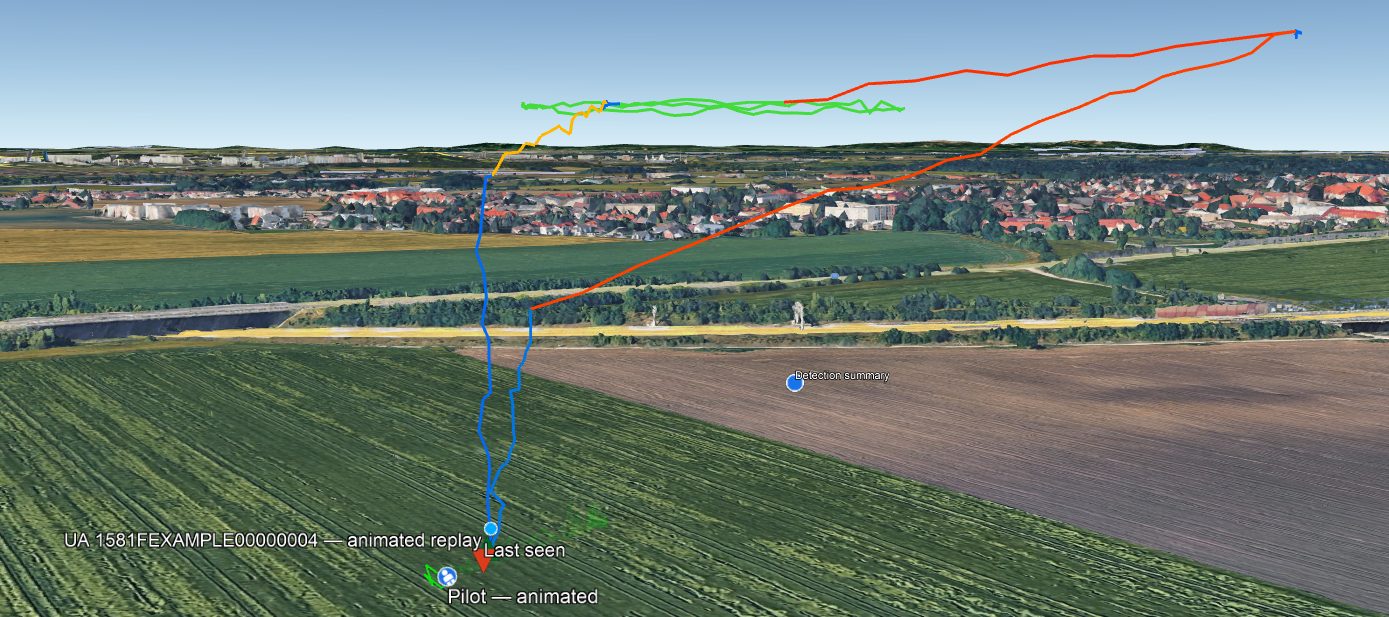
| Layer | Looks like | What it shows |
|---|---|---|
| Aircraft | Light-blue dot with a white rim | The drone. It moves when you replay the flight. |
| Path | Line coloured by speed | The whole track. Blue is slow, red is fast. The legend in the corner gives the values. |
| Pilot | White figure on a blue disc | Where the pilot was. It moves with the replay. Detections only. |
| Take-off point | Orange take-off symbol on a white disc | Shown when the drone sent its take-off location instead of the pilot's position. Detections only. |
| First seen | Green triangle pointing up | The first recorded position |
| Last seen | Red triangle pointing down | The last recorded position |
| Summary | Blue dot with a white rim, in the middle of the track | Click it for the summary |
| Operation area | Outlined area | The area declared for the flight, when there is one. Flights only. |
First seen and last seen are not the take-off and landing. A receiver starts hearing a drone when it comes into range, often in mid-flight.
Turned Off When You Open the File
Tick these in the Places panel when you need them.
| Layer | What it shows |
|---|---|
| Altitude curtain | A wall from the track down to the ground, which makes the height easier to see |
| Velocity arrows | Arrows in the direction of travel. Click one for the speed and time. |
| Tethers | Lines from the drone to the pilot or take-off point, with the distance. Detections only. |
The Summary
Click the summary dot to see what the aircraft was, its identifiers and operator, when it was first seen, how long and how far it flew, its top speed and its greatest heights. A detection also shows the largest distance from the pilot and the receivers that heard it.
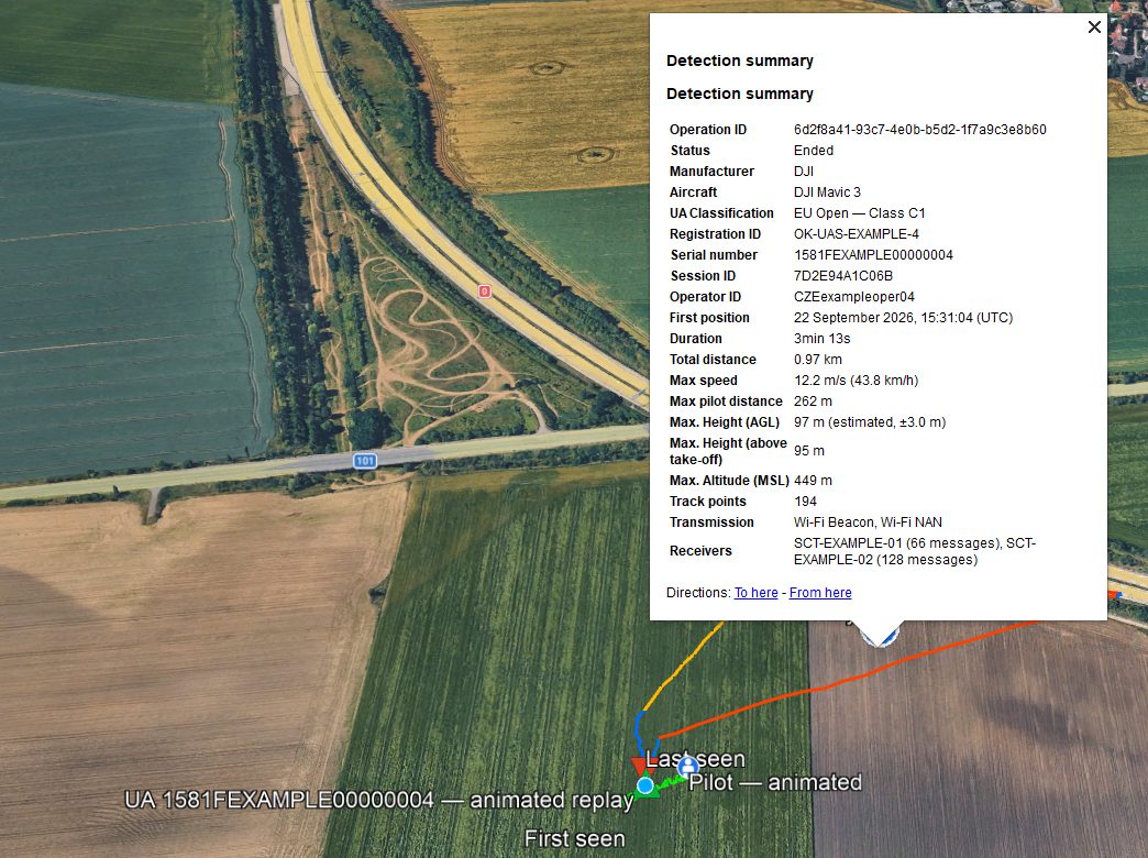
A few rows use different names from the CSV and JSON.
| In the KMZ | In CSV and JSON |
|---|---|
| Callsign | callsign (JSON: custom_callsign) |
| Description | The Self-ID text the drone sent. JSON only. |
| First position | time_first_telemetry |
| Max. Height (AGL) | max_alt_agl |
A record with no positions shows Start instead of First position.
Replaying a Flight
Use the time slider at the top of the map. Press play or drag it. If you don't see the slider, choose View → Show Time.
The Follow the aircraft tour flies the camera along the track. Find it in the Places panel and press play.
Units, Times and Credits
Distances, speeds and heights are in metric units, or imperial ones where the place you export from lets you choose. Times are in UTC, for example "15:31:04 (UTC)".
If the heights above ground came from terrain data that must be credited, the credit is in the description of each flight's folder, under Terrain data. See Terrain Data and Attribution.
Terrain Data and Attribution
To work out how high a drone was above the ground, Dronetag needs to know how high the ground is. That comes from terrain models, maps of ground height published by survey agencies and space programmes. Some of them may only be used if you credit them. This page says what you need to keep when you pass exported data on.
What Terrain Data Is Used For
Terrain data gives the height above the ground (AGL) at every point.
It is also used for the sea-level altitude (MSL) in one case. When the drone reported no GPS height, Dronetag reads the ground height at the take-off point and adds the height above take-off.
Terrain Models
Dronetag can use the terrain models below. For each place it uses the most detailed one available.
| Model | Covers | Detail | Measures | Credit needed |
|---|---|---|---|---|
| ČÚZK DMR 5G | Czechia | 5 m | Bare ground | Yes |
| USGS 3DEP | United States | About 30 m | Bare ground | No |
| Copernicus DEM GLO-30 | Most of Europe | 30 m | Surface | Yes, with a disclaimer |
| NOAA ETOPO 2022 | The whole world | About 1 to 2 km | Bare ground | No |
The map shows which model is used where. Drag it to move around and use the buttons to zoom in. Click an area or a model name to see its details.
Click a coloured area or a model above to see its details.
The Copernicus models measure the top of trees and buildings. Over forest or in towns, the height above the ground reads low by about the height of the trees or roofs.
Where the Credits Are
An export carries credits only for the terrain it actually used, and only when that terrain needs a credit.
| Format | Where to find the credits |
|---|---|
| CSV | The download is a zip with the CSV and ATTRIBUTION.txt. If no credit is needed, you get the plain CSV. |
| JSON | The attribution key at the end of the file |
| KMZ | The description of each flight's folder, under Terrain data |
| The Terrain Data section of the report |
What ATTRIBUTION.txt Contains
ATTRIBUTION.txt is a short English text file in UTF-8. It names the CSV it belongs to and the columns whose values came from terrain data. These are alt_agl and alt_msl in CSV Telemetry, and max_alt_agl and max_alt_msl in CSV Summary. Then it lists each terrain model with three parts.
- The notice is the credit, word for word as the licence asks for it.
- The disclaimer appears only when the licence asks for one. Copernicus does.
- The licence line names the licence and links to it.
Lines are wrapped, but the wording never changes. A complete example is in ATTRIBUTION.txt.

Why the Credits Must Stay With the Data
The licences let you use and share the heights as long as the credit goes with them.
- Keep
ATTRIBUTION.txtwith the CSV when you send, upload or publish it. - Keep the
attributionblock when you pass the JSON on. - If you publish something built from these heights, such as a chart or a report, include the notice texts exactly as written. Some licences require the exact wording.
If you are unsure what a licence allows, read it through the link in the file or ask the data provider.
Source pages
Every chapter of this document is a page of the Dronetag help site. Use these addresses to reach the latest version.
- 1Which Export to Choosehelp.dronetag.cz/developers/export-formats/which-export-to-choose
- 2CSV Telemetryhelp.dronetag.cz/developers/export-formats/csv-telemetry
- 3CSV Summaryhelp.dronetag.cz/developers/export-formats/csv-summary
- 4JSONhelp.dronetag.cz/developers/export-formats/json
- 5Altitudes Explainedhelp.dronetag.cz/developers/export-formats/altitudes-explained
- 6KMZ for Google Earthhelp.dronetag.cz/developers/export-formats/kmz
- 7Terrain Data and Attributionhelp.dronetag.cz/developers/export-formats/terrain-data-and-attribution